Digital MRV: The Catalyst for Scale, Trust, and Maturity in Global Voluntary Carbon Markets
The Voluntary Carbon Market (VCM) offers businesses, institutions, and individuals a platform to channel billions of dollars into vital climate finance, supporting impactful initiatives that promote ecosystem restoration and long-term conservation efforts to fulfill global long-term environmental and sustainability goals. Central to the promise of the VCM is the commitment to back nature-based solutions (NbS) projects that result in tangible reduction, removal, avoidance or sequestration of greenhouse gas emissions, monetized through the issuance by recognized standards of tradable carbon credits. However, validating these assertions with unyielding confidence has been a historic challenge.
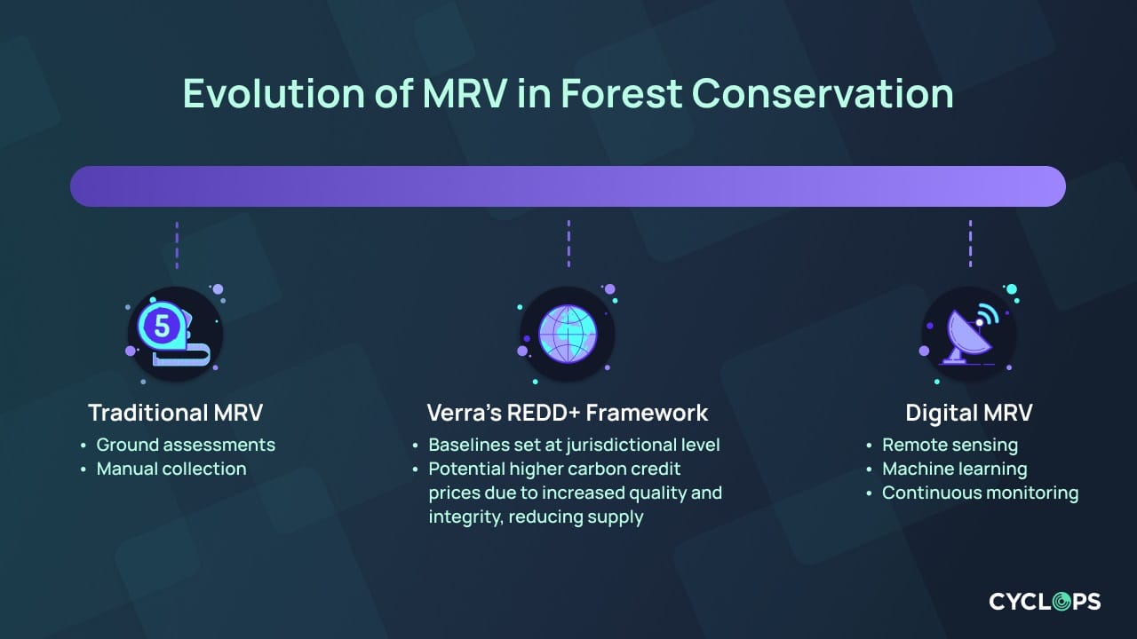
Traditional methodologies employed in the VCM have been fraught with limitations. For one, they predominantly rely on manual audits, which are time-consuming, limited in areas covered, expensive, and susceptible to human biases and errors. In addition, these conventional approaches often hinge on human-led checks and intermittent site visits, offering only sporadic snapshots rather than continuous oversight. This sporadic nature extends the verification timeline and can introduce assessment variability, causing potential discrepancies in data interpretation and reporting standards, often resulting in inaccurate baseline calculations and leading to overcrediting, ultimately contributing to a confidence crisis.
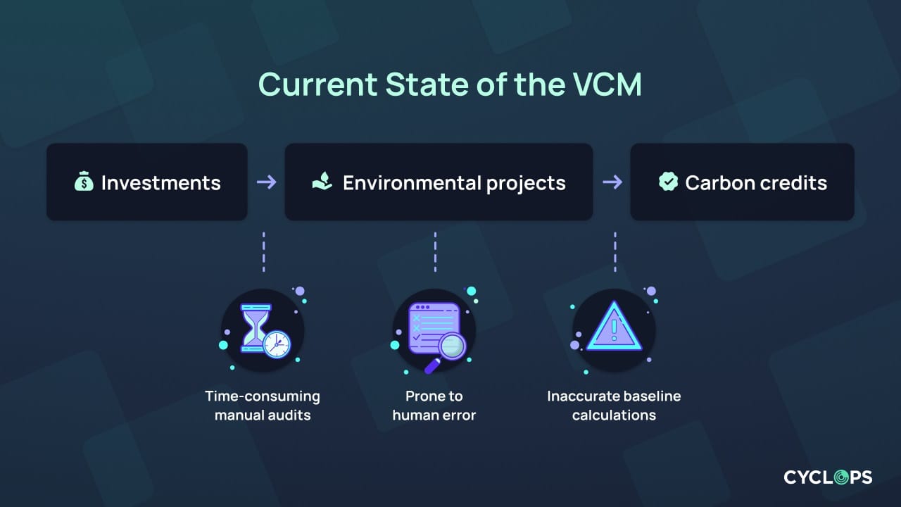
The need to scale the VCM amplifies the urgency of addressing these challenges. As per recent forecasts, the VCM is on a trajectory to handle several billions in investments in the foreseeable future, emphasizing the magnitude of environmental and financial stakes. In 2021, the VCM hit for the first time the $1 billion mark in total value. The trend continued in 2022 with a total value at just under $2 billion with market projections ranging from $50 billion to $1trillion. The projected growth for these markets underscores the need for a system that offers real-time, transparent, consistent, and efficient monitoring to foster trust among all stakeholders—investors, project developers, end-buyers, and the wider public.
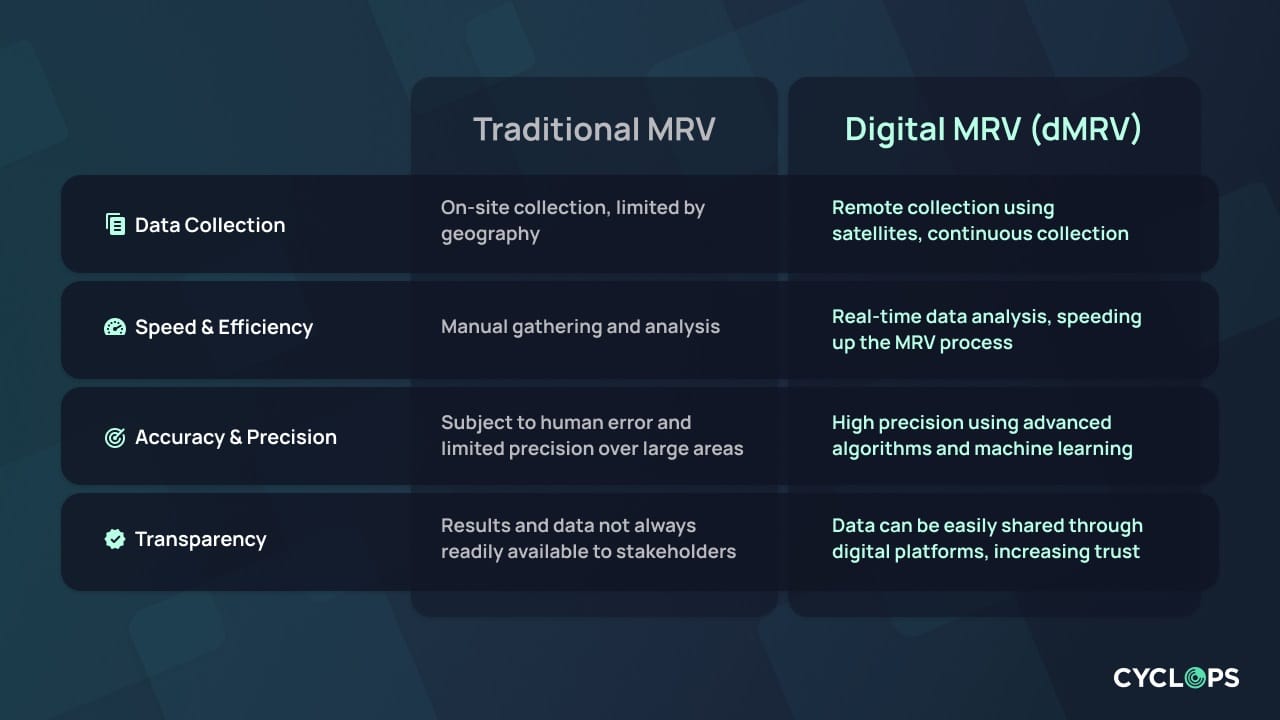
Measurement, Reporting, and Verification (MRV) is a crucial component in carbon markets, serving as the backbone for assessing and validating carbon projects. MRV processes ensure the transparency and integrity of carbon credits by meticulously measuring the carbon emissions reduced or sequestered, reporting these emission reductions accurately, and verifying them through independent third parties or registry-approved validation and verification bodies (VVB’s). This system ensures that carbon projects contribute genuine, quantifiable environmental benefits, building trust within the carbon market ecosystem.
In carbon markets, MRV is not just a procedural formality; it's the linchpin that maintains the market's credibility. Every carbon credit issued represents a tangible reduction in greenhouse gasses. This claim must be substantiated through rigorous MRV processes. These procedures are vital to ensuring that carbon markets fulfill their intended purpose: to provide a reliable, transparent mechanism for offsetting emissions and facilitating meaningful climate action. Through MRV, carbon markets can effectively channel investments into projects that yield verifiable environmental benefits, turning the wheels of environmental and sustainable development worldwide.
Digital MRV: Paving the Way to Scale the VCM
Digital MRV (dMRV) revolutionizes the traditional approach to MRV by integrating advanced satellite technology, remote sensing capabilities, and artificial intelligence (AI). While scaling the VCM is often defined as the amount of investments needed in carbon projects, dMRV will also significantly contribute to broadening the size of project development: this shift from ground-based to aerial data collection offers a more expansive and detailed view of carbon projects, especially in remote and inaccessible areas. Satellites equipped with high-resolution cameras and sensors can continuously monitor large swathes of land, capturing changes in forest cover, biomass, and other key environmental indicators with unparalleled precision. This continuous monitoring allows for the detection of even minor deviations from expected patterns, ensuring that any carbon sequestration or emissions are accurately accounted for.
Remote Sensing for Real-time Monitoring
The rise of digital technology has brought forth an array of tools to track, evaluate, and quickly respond to environmental changes on our planet. Foremost among these is remote sensing, which has emerged as a pivotal instrument in monitoring natural capital.
Remote sensing involves acquiring data about the Earth's surface without making direct contact. This technology, particularly when taken from satellites, has the unparalleled capability to observe vast ecosystems—from dense rainforests to expansive grasslands and intricate wetlands. Such broad coverage offers a holistic perspective, which traditional ground-based monitoring methods often fail to achieve.
A noteworthy advantage of remote sensing is its continuity. Unlike human-led inspections, which are typically intermittent and can be hindered by factors such as challenging terrains or political restrictions, satellites provide continuous oversight. This constant vigilance ensures that environmental changes, subtle or significant, are promptly detected and reported. This way, remote sensing eradicates the uncertainty and lag often associated with manual, on-ground inspections.
However, it is not just about detection—remote sensing, coupled with advanced algorithms, has opened the doors to dynamic project baselining. Traditional monitoring often relies on fixed and limited benchmarks, which could quickly become outdated given the rapid pace of environmental change. However, by leveraging the real-time data that satellites provide, dynamic baselines can be established and regularly revised (World Economic Forum, 2022). This ensures that any environmental health or project impact assessment is continually juxtaposed against a current and relevant yardstick.
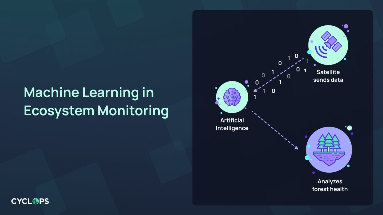
Furthermore, integrating remote sensing with other advanced technologies amplifies its impact. For instance, pairing satellite data with machine learning and AI models enables the automated recognition of patterns and trends. These models can "learn" how a forest should evolve or what a flourishing wetland looks like, thus instantly flagging any anomalies or potential concerns, from deforestation to shifts in biomass and carbon stock.
Machine Learning and Its Mastery over Forest Health Analysis
Machine learning, a branch of artificial intelligence, has steadily become a cornerstone in ecosystem monitoring and Digital MRV. The complex and multifaceted nature of forests, with their varied species, growth rates, and health indicators, requires an analytical tool beyond basic data crunching. With their sophisticated algorithms, machine learning models rise to this challenge with unmatched precision.
These models do not just process data; they learn from it. When fed vast amounts of satellite imagery, these algorithms sift, analyze, and identify patterns crucial to determining forest health. Machine learning provides eagle-eyed surveillance, from monitoring tree density and canopy cover to even discerning subtle changes in tree health due to pests or diseases. Furthermore, its capability to detect unauthorized deforestation activities or sudden shifts in biomass provides a safety net against potential malpractices and environmental threats.
However, what sets machine learning models apart is its self-improving nature. Each dataset it processes refines its subsequent analyses, enhancing its ability to discern forest-related nuances. As a result, the more data it is exposed to, the sharper and more precise its monitoring becomes. Such continuous evolution ensures up-to-date insights and reinforces the gold standard in natural capital monitoring, ensuring our forest health assessments remain cutting-edge.
Incorporating generative AI techniques into Digital MRV further enhances its capabilities, especially in terms of modeling forest growth and predicting future trends. These advanced AI models can generate synthetic data that replicate complex natural processes, providing a deeper understanding of forest dynamics over time. By analyzing historical satellite imagery and environmental data, generative AI can create detailed simulations of how forests have evolved, unveiling patterns of growth, decline, and recovery. This historical perspective is crucial for establishing accurate baselines against which current and future forest conditions can be measured. This allows standards and registries to generate and end-users to buy credible carbon credits.
Moreover, these AI models are not limited to retrospective analysis. They extend their utility into the realm of predictive forecasting, enabling project developers and stakeholders to anticipate future scenarios. For example, they can simulate the impact of various environmental factors on forest health, such as changes in climate patterns, natural disasters, or human interventions. This predictive capability is particularly valuable for assessing the risks of deforestation and devising proactive strategies to mitigate these risks. It allows for the forecasting of potential hotspots of illegal logging or areas susceptible to rapid degradation, enabling timely interventions.
Leveraging recent advancements in satellite technology and emerging technologies like AI, Digital MRV offers a more dynamic, real-time approach to monitoring, capable of adapting to the evolving nature of nature based projects and environmental conditions. This not only strengthens the integrity of carbon credits but also fosters a more responsive and responsible carbon market.
Improved Data & Digital MRV Infrastructure + Revamped Methodologies Are Crucial
The imperative need for rigorous methodologies and comprehensive data and MRV systems to instill integrity in the the VCM is clearly demonstrated by the introduction of Verra's new REDD+ framework whereby REDD+ projects baseline, set at the jurisdiction level, will be independently assessed by Verra using 3rd party digital MRV providers. Tarnished by several recent controversies, this approach represents a significant advancement in forest protection strategies within the VCM, highlighting the critical role of meticulous, independent methodologies and robust data systems in enhancing market credibility and limiting potential conflict of interest. The new Verra methodology marks a notable shift in forest conservation efforts, characterized by the integration of a jurisdictional approach to establish project baselines, leveraging on newly implemented geospatial deforestation tools. This innovative methodology effectively aligns project-level actions with broader global and governmental climate initiatives, fostering a more unified and impactful approach to forest conservation. This shift in assessing independently project baselines and leveraging on refined data infrastructure could result in higher carbon credit prices on the back of improved quality and integrity, and reduced supply.
Moreover, the integration of advanced technologies like satellite remote sensing and AI-driven analytics into MRV processes is underscored by such methodologies. These technologies provide essential granularity and accuracy in data collection, enabling more precise monitoring of forest carbon stocks and changes. By combining rigorous methodologies with cutting-edge data systems, the VCM can achieve a higher standard of environmental integrity, ensuring each carbon credit genuinely contributes to global climate mitigation.
The VCM serves a pivotal purpose: catalyzing concrete emissions reductions in our fight against climate change. At its heart lies the commitment to genuine, impactful initiatives. However, noble intentions require robust verification mechanisms to transform into tangible outcomes.
This is where Digital MRV, fortified by state-of-the-art technologies, steps in. The essence of Digital MRV is to ensure the integrity of each carbon credit produced. By leveraging technologies such as remote sensing, machine learning, and geospatial intelligence, Digital MRV offers an oversight mechanism for projects that is both meticulous and transparent (World Economic Forum, 2022).
Pioneering the New Era of Global Voluntary Carbon Markets with CYCLOPS
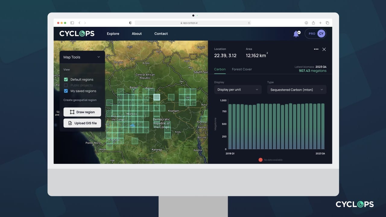
At the forefront of ensuring the integrity of VCM projects, CYCLOPS, dClimate’s proprietary platform, stands as a paradigm of technological innovation for measuring carbon stocks and for the monitoring of nature based projects and natural capital. Anchored by advanced AI technologies, CYCLOPS excels in analyzing satellite imagery to detect critical environmental changes, particularly deforestation, and precisely measure biomass within various regions. This AI-driven approach, refined through continuous learning and enriched with expansive datasets, enables CYCLOPS to identify and assess the health of forested areas with remarkable accuracy.
CYCLOPS transcends traditional monitoring methods by integrating a mix of medium to high-resolution optical and RADAR satellite imagery, supplemented by ground data checks. This comprehensive approach creates a detailed spatiotemporal land cover map, capturing nuanced changes in forest ecosystems. The platform is uniquely capable of quantifying biomass loss and converting these changes into carbon emissions values, thus providing a comprehensive emission profile. This dynamic system adapts to evolving forest conditions, ensuring up-to-date and precise monitoring.
Further enhancing its capabilities, CYCLOPS introduces a refined methodology using high-resolution imagery to detect and differentiate various disturbances such as illegal logging, offering unparalleled precision for localized monitoring.
To date, CYCLOPS has monitored 400 million hectares of forest worldwide with the goal of completing a high-frequency global biomass and deforestation detection model by late 2024, providing high-resolution and granular verification and monitoring for REDD+, ARR, and related forest carbon/nature-based projects.
CYCLOPS is not just a tool; it's a commitment to environmental accountability. With the goal of validating governmental inventories and industry-reported deforestation activities, CYCLOPS is poised to become a leader and a benchmark in the carbon credit sector. By addressing the long-standing challenges of trust and efficiency in carbon markets, CYCLOPS is paving the way for a future where every carbon credit is a testament to genuine, verifiable environmental preservation.
Stay connected with CYCLOPS for the latest insights and updates by following us on Twitter and LinkedIn!